Blog GIS & Territories

GIS coaching for territorial management.

  • Blog – English
  • Tutorials
    • Leaflet Initiation
  • All Content
  • Old Maps
  • Plugins QGis(en)
    • S57Manager(en)
    • FuzzyAttributes(en)
  • About/Contact
  • English
    • Français
    • English
    • Español
    • Português

Tag: enc

11 February 20263 February 2026 Atilio Francois No Comments
  • Plugin
  • QGis
  • S57

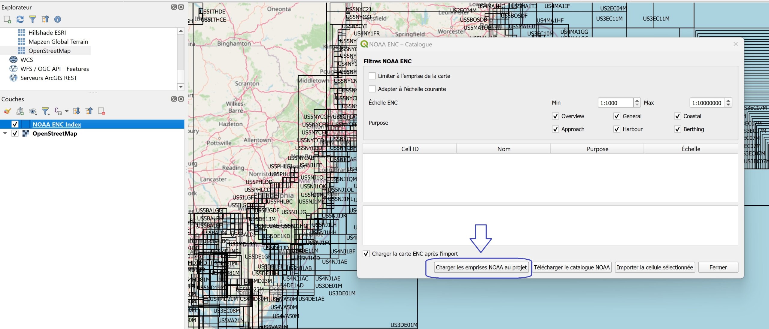
[EN]Import NOAA ENC nautical charts directly into QGIS with S57Manager

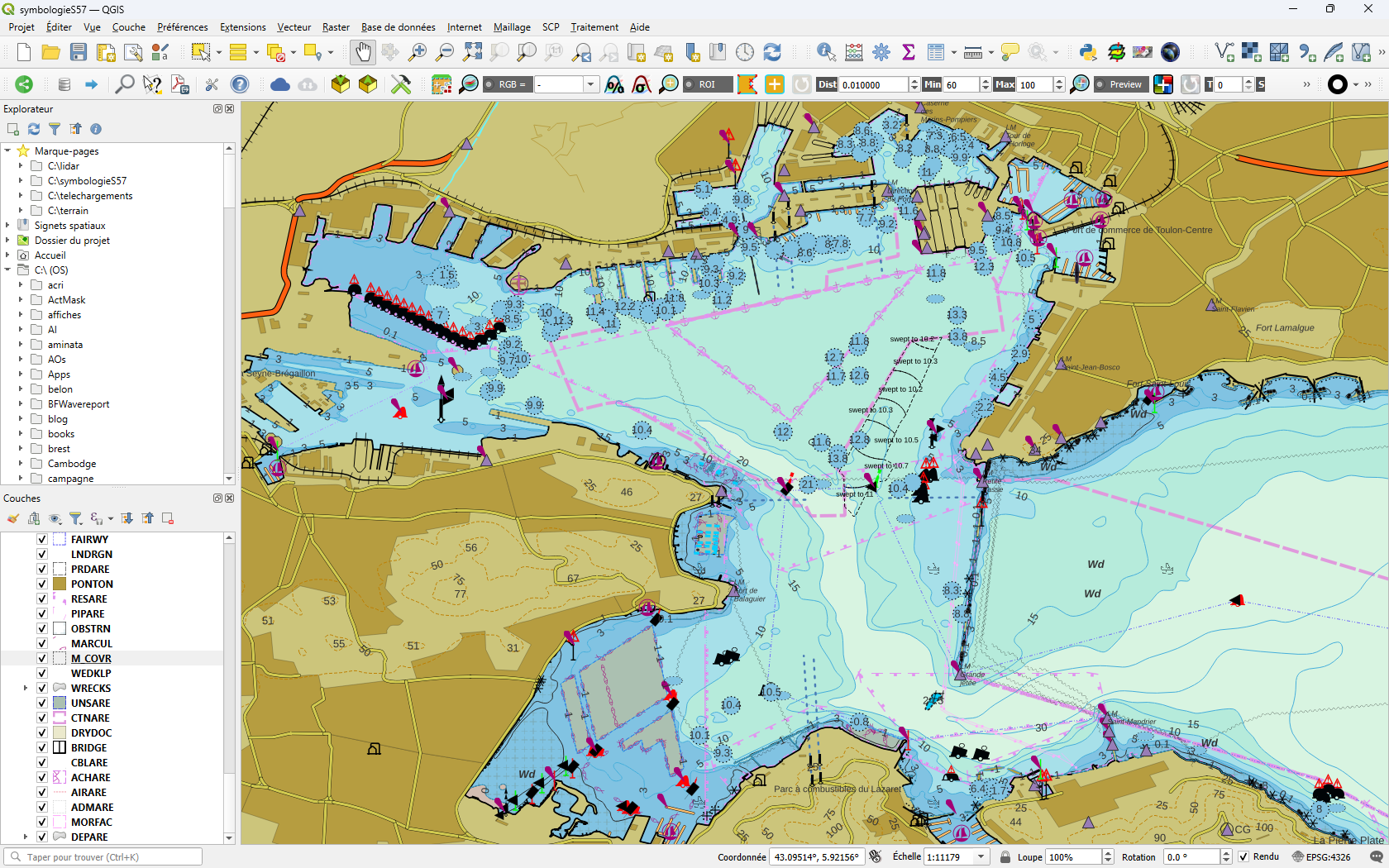
ENC (Electronic Navigational Charts) are now the standard for digital marine cartography. With the latest update to the S57Manager plugin, QGIS now features a module dedicated to the official NOAA ENC catalog, allowing users to easily…

Read More
4 February 20263 February 2026 Atilio Francois No Comments
  • Plugin
  • QGis
  • S57

[EN]S57Manager: Working with ENC S-57 data in QGIS using GeoPackage

A lightweight, autonomous and portable solution for marine data Introduction While PostGIS is ideal for structured, collaborative and multi-project professional environments, it is not always necessary — nor desirable — for all use cases. For: the…

Read More
4 June 20254 June 2025 Atilio Francois No Comments
  • Postgis
  • PostgreSQL

ENC maps in QGis with Postgis(1)

This subject comprises two articles. The first deals with importing ENC S57 files into a Postgresql/postgis database. The second deals with setting up an automatic symbology equivalent to nautical charts. You can download all the scripts…

Read More
16 April 202416 April 2024 Atilio Francois No Comments
  • QGis

Tools for ENC marine map projects in QGis

This article completes the series of articles on creating a geopackage database to manage ENC nautical charts in QGis and the symbology of the various data layers. Working with a small number of maps presents no…

Read More
19 December 202318 December 2023 Atilio Francois 2 Comments
  • QGis

Displaying S57 nautical charts in QGis 3.X

In this article you’ll find out how to load an ENC file in S57 format into QGis 3.34 and download a nautical chart symbology to apply to it. As the previous article on the S57 format…

Read More

Mastodon Follow me on Mastodon
Voir le profil de atilio francois sur LinkedIn

Recent articles

Recent comments

posts

  1. Atilio Francois on [EN]Portable QGIS 4.0 for Windows – Download and use QGIS without installation5 June 2026

    Thank you for your feedback and for reporting these issues. The errors and the missing Processing functionality that you observed…

  2. Andrea on [EN]Portable QGIS 4.0 for Windows – Download and use QGIS without installation5 June 2026

    I've downloaded today the 7z file from https://www.sigterritoires.fr/QGis4.0Lite, then unarchived it and then launched launch_qgis_portable.bat: various errors occurs https://dcmnt.eu/pad/#/2/pad/view/-6FZXEyJYV4SyZmDWWE4XW6M7l-1JGp0V67X4tBTdjg/embed/ and…

  3. Andrea on [EN]Portable QGIS 4.0 for Windows – Download and use QGIS without installation5 June 2026

    It's not clear what are exactly the components that are missing in the "QGIS portable – lightweight version". Could you…

  4. Ed on Portable version of QGis 3.44.0 – Updated Version with Python Fixes and Authentication Support2 June 2026

    Thank you for your service to the community! Please know that you are greatly appreciated! We prefer using the Long…

  5. SERGIO SEBASTIAN VERDU on [EN]Portable QGIS 4.0 for Windows – Download and use QGIS without installation27 May 2026

    Hi Atilio, I'm very interested in downloading these versions of QGIS, but I've tried several times and the download never…

All articles by category (click on a category to display article extracts)

(You can copy the RSS link for each category separately)

  • ArcGis (1)
  • Arcgis Pro (1)
  • bibliography (1)
  • Database (13)
    • PostgreSQL (9)
    • Spatialite (3)
  • english posts (20)
  • Felt (3)
  • Geoserver (5)
  • Geospatial Technologies (4)
    • Spatial Analysis & GIS (4)
  • GIS and management (2)
  • IA(en) (3)
  • Lidar (10)
  • Logique floue (2)
  • Non classé (207)
  • Outils divers (2)
  • Outils et méthodes (5)
    • Images (5)
  • Postgis (4)
  • QGis (81)
    • Plugin (27)
    • Tutorial (6)
  • S57 (5)
  • webmapping (9)

  • Blog – English
  • Tutorials
  • All Content
  • Old Maps
  • Plugins QGis(en)
  • About/Contact
  • English
Copyright 2018. All rights reserved | Theme: Blog Mantra by LilyTurf Themes