Blog GIS & Territories

GIS coaching for territorial management.

  • Blog – English
  • Tutorials
    • Leaflet Initiation
  • All Content
  • Old Maps
  • Plugins QGis(en)
    • S57Manager(en)
    • FuzzyAttributes(en)
  • About/Contact
  • English
    • Français
    • English
    • Español
    • Português

Tag: fuzzyattributes

27 October 202525 October 2025 Atilio Francois No Comments
  • Logique floue
  • Plugin

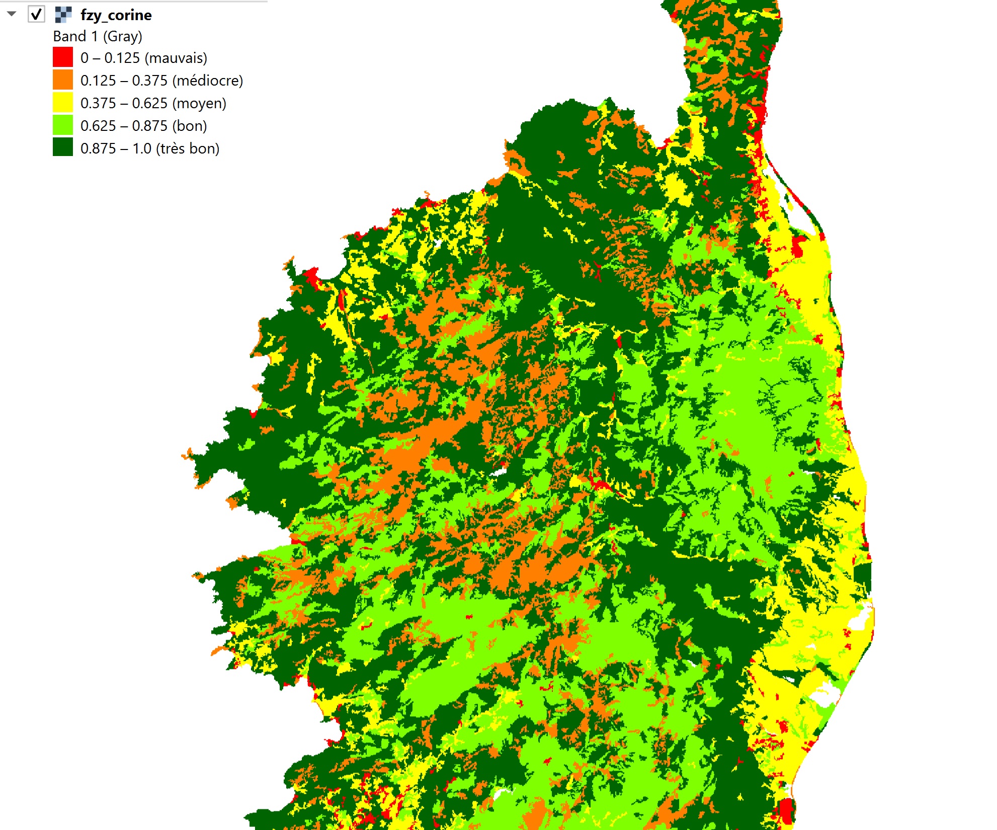
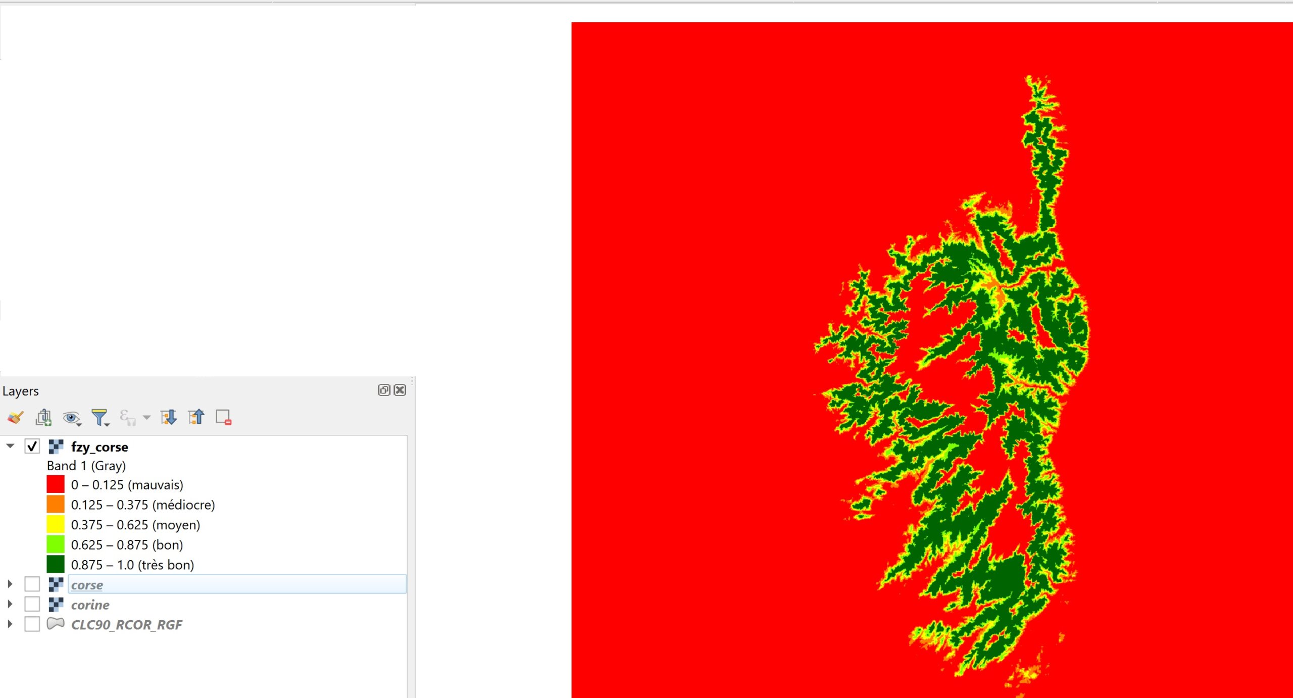
Fuzzy aggregation of two raster layers with FuzzyAttributes V2

After the two articles on converting a raster to fuzzy values: We will sees dans cet article comment agréger deux rasters flous en prenant en compte la subjectivité de l’utilisateur. Settings window In the FuzzyAttributes plugin…

Read More
20 October 202519 October 2025 Atilio Francois No Comments
  • Plugin
  • QGis

Converting a class raster to a fuzzy raster in QGIS

In some cases, the data is not continuous (altitude, slope, distance, etc.), but discrete, i.e., consisting of classes. Each pixel then corresponds to a category: a soil type, land use, risk level, etc. These “categorical” rasters…

Read More
13 October 202514 October 2025 Atilio Francois No Comments
  • Plugin
  • QGis

Converting a raster into fuzzy values with FuzzyAttributes V2

Version 2 of FuzzyAttributes extends the plugin’s capabilities by directly integrating fuzzy transformation of rasters, in addition to vector attributes and text → fuzzy mapping. This allows you to work on continuous data (e.g., indices, altitudes,…

Read More
6 October 202514 October 2025 Atilio Francois No Comments
  • Plugin
  • QGis

Consultation and negotiation: the contribution of fuzzy logic

Consultation and negotiation: understanding, dialogue, building together In regional, environmental, or development projects, decisions can no longer be imposed unilaterally. Stakeholders—whether citizens, institutions, businesses, or associations—expect to be listened to, consulted, and involved. Two approaches are…

Read More
17 September 20258 September 2025 Atilio Francois No Comments
  • Plugin

From Boolean analysis to fuzzy logic in a GIS: a concrete example

Introduction In spatial analysis, criteria are often applied strictly: yes/no, inside/outside, above/below a threshold. But reality is rarely so clear-cut: is a municipality with 4,900 inhabitants really so different from another with 5,100? Fuzzy logic allows…

Read More
4 September 202524 August 2025 Atilio Francois No Comments
  • Plugin
  • QGis

Fuzzy logic and GIS (2/2): from transformation to aggregation of spatial data

In the first part of this series, we saw how fuzzy logic allows us to go beyond rigid thresholds by assigning each spatial entity a degree of membership between 0 and 1.We explored several membership functions,…

Read More

Posts pagination

1 2 Next »

Mastodon Follow me on Mastodon
Voir le profil de atilio francois sur LinkedIn

Recent articles

Recent comments

posts

  1. Atilio Francois on [EN]Portable QGIS 4.0 for Windows – Download and use QGIS without installation5 June 2026

    Thank you for your feedback and for reporting these issues. The errors and the missing Processing functionality that you observed…

  2. Andrea on [EN]Portable QGIS 4.0 for Windows – Download and use QGIS without installation5 June 2026

    I've downloaded today the 7z file from https://www.sigterritoires.fr/QGis4.0Lite, then unarchived it and then launched launch_qgis_portable.bat: various errors occurs https://dcmnt.eu/pad/#/2/pad/view/-6FZXEyJYV4SyZmDWWE4XW6M7l-1JGp0V67X4tBTdjg/embed/ and…

  3. Andrea on [EN]Portable QGIS 4.0 for Windows – Download and use QGIS without installation5 June 2026

    It's not clear what are exactly the components that are missing in the "QGIS portable – lightweight version". Could you…

  4. Ed on Portable version of QGis 3.44.0 – Updated Version with Python Fixes and Authentication Support2 June 2026

    Thank you for your service to the community! Please know that you are greatly appreciated! We prefer using the Long…

  5. SERGIO SEBASTIAN VERDU on [EN]Portable QGIS 4.0 for Windows – Download and use QGIS without installation27 May 2026

    Hi Atilio, I'm very interested in downloading these versions of QGIS, but I've tried several times and the download never…

All articles by category (click on a category to display article extracts)

(You can copy the RSS link for each category separately)

  • ArcGis (1)
  • Arcgis Pro (1)
  • bibliography (1)
  • Database (13)
    • PostgreSQL (9)
    • Spatialite (3)
  • english posts (20)
  • Felt (3)
  • Geoserver (5)
  • Geospatial Technologies (4)
    • Spatial Analysis & GIS (4)
  • GIS and management (2)
  • IA(en) (3)
  • Lidar (10)
  • Logique floue (2)
  • Non classé (207)
  • Outils divers (2)
  • Outils et méthodes (5)
    • Images (5)
  • Postgis (4)
  • QGis (80)
    • Plugin (26)
    • Tutorial (6)
  • S57 (5)
  • webmapping (9)

  • Blog – English
  • Tutorials
  • All Content
  • Old Maps
  • Plugins QGis(en)
  • About/Contact
  • English
Copyright 2018. All rights reserved | Theme: Blog Mantra by LilyTurf Themes