Blog GIS & Territories

GIS coaching for territorial management.

  • Blog – English
  • Tutorials
    • Leaflet Initiation
  • All Content
  • Old Maps
  • Plugins QGis(en)
    • S57Manager(en)
    • FuzzyAttributes(en)
  • About/Contact
  • English
    • Français
    • English
    • Español
    • Português

Author: Atilio Francois

12 January 202610 January 2026 Atilio Francois No Comments
  • IA(en)
  • Images
  • QGis

Improving aerial image resolution with ESRGAN: when AI brings old photos back to life

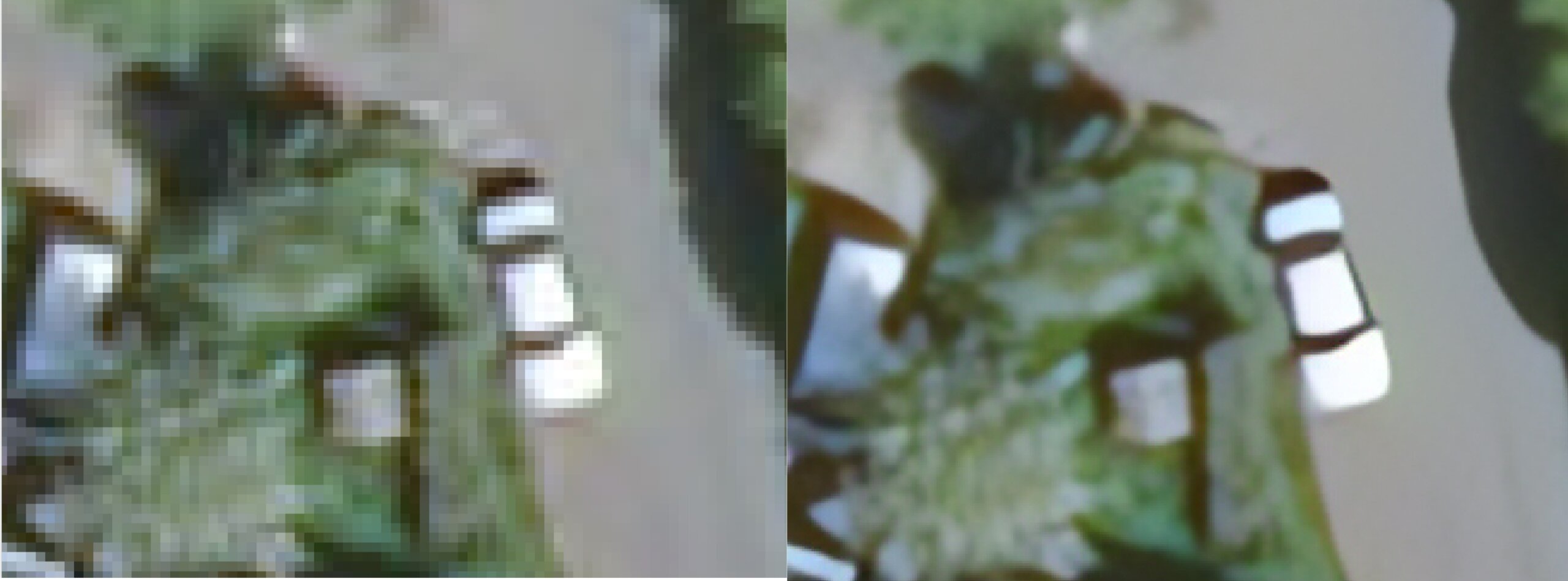
Aerial images are a gold mine: old surveys, forest inventories, coastal monitoring, digitized cadastral maps, etc. But they often suffer from a major problem: low resolution. Blurring, pixelation, crushed textures, loss of detail… these are all…

Read More
5 January 202627 December 2025 Atilio Francois No Comments
  • Plugin
  • QGis

QGIS: AI comes to plugins – notable new features in December

New plugins, new practices: December illustrates the richness and diversity of the QGIS ecosystem. Between artificial intelligence, business productivity, and external data integration, these extensions open up concrete opportunities for geomatics professionals. December confirms a clear…

Read More
15 December 2025 Atilio Francois No Comments
  • IA(en)

Sentinel-2 with 1 m resolution: towards a more detailed analysis of coastal environments

In two previous articles, we explored how to convert standard Sentinel-2 images (10 m resolution) to a super-resolution 1 m version using the S2DR3 module, developed for coral research in Mauritius. This step provides an unprecedented…

Read More
8 December 202528 November 2025 Atilio Francois No Comments
  • Plugin
  • QGis

New QGIS plugins – November 2025

November brings a host of new developments to the QGIS extension ecosystem. Once again, the open source community demonstrates its dynamism with a variety of tools, ranging from basic mapping to advanced spatial analysis workflows, productivity,…

Read More
1 December 202528 November 2025 Atilio Francois No Comments
  • IA(en)

When Deep Learning Dives Beneath the Surface: Mapping Corals with QGIS and PyTorch

Deep learning is revolutionizing satellite image analysis. Long reserved for large laboratories or proprietary software, it is now becoming available to the wider world thanks to PyTorch and QGIS. This article explores the principles of Deep…

Read More
17 November 202511 November 2025 Atilio Francois No Comments
  • Images
  • Plugin

Study of corals with Sentinel-2 Deep Resolution 3 (S2DR3) using QGis and SCP

Following on from the article “How to increase the resolution of Sentinel 2 images from 10 to 1m” and “Using S2DR3 in Google Colab to study corals in Mauritius,” let’s take a look at how to…

Read More

Posts pagination

« Previous 1 … 3 4 5 6 7 … 58 Next »

Mastodon Follow me on Mastodon
Voir le profil de atilio francois sur LinkedIn

Recent articles

Recent comments

posts

  1. Atilio Francois on [EN]Portable QGIS 4.0 for Windows – Download and use QGIS without installation5 June 2026

    Thank you for your feedback and for reporting these issues. The errors and the missing Processing functionality that you observed…

  2. Andrea on [EN]Portable QGIS 4.0 for Windows – Download and use QGIS without installation5 June 2026

    I've downloaded today the 7z file from https://www.sigterritoires.fr/QGis4.0Lite, then unarchived it and then launched launch_qgis_portable.bat: various errors occurs https://dcmnt.eu/pad/#/2/pad/view/-6FZXEyJYV4SyZmDWWE4XW6M7l-1JGp0V67X4tBTdjg/embed/ and…

  3. Andrea on [EN]Portable QGIS 4.0 for Windows – Download and use QGIS without installation5 June 2026

    It's not clear what are exactly the components that are missing in the "QGIS portable – lightweight version". Could you…

  4. Ed on Portable version of QGis 3.44.0 – Updated Version with Python Fixes and Authentication Support2 June 2026

    Thank you for your service to the community! Please know that you are greatly appreciated! We prefer using the Long…

  5. SERGIO SEBASTIAN VERDU on [EN]Portable QGIS 4.0 for Windows – Download and use QGIS without installation27 May 2026

    Hi Atilio, I'm very interested in downloading these versions of QGIS, but I've tried several times and the download never…

All articles by category (click on a category to display article extracts)

(You can copy the RSS link for each category separately)

  • ArcGis (1)
  • Arcgis Pro (1)
  • bibliography (1)
  • Database (13)
    • PostgreSQL (9)
    • Spatialite (3)
  • english posts (20)
  • Felt (3)
  • Geoserver (5)
  • Geospatial Technologies (4)
    • Spatial Analysis & GIS (4)
  • GIS and management (2)
  • IA(en) (3)
  • Lidar (10)
  • Logique floue (2)
  • Non classé (207)
  • Outils divers (2)
  • Outils et méthodes (5)
    • Images (5)
  • Postgis (4)
  • QGis (82)
    • Plugin (28)
    • Tutorial (6)
  • S57 (5)
  • webmapping (9)

  • Blog – English
  • Tutorials
  • All Content
  • Old Maps
  • Plugins QGis(en)
  • About/Contact
  • English
Copyright 2018. All rights reserved | Theme: Blog Mantra by LilyTurf Themes