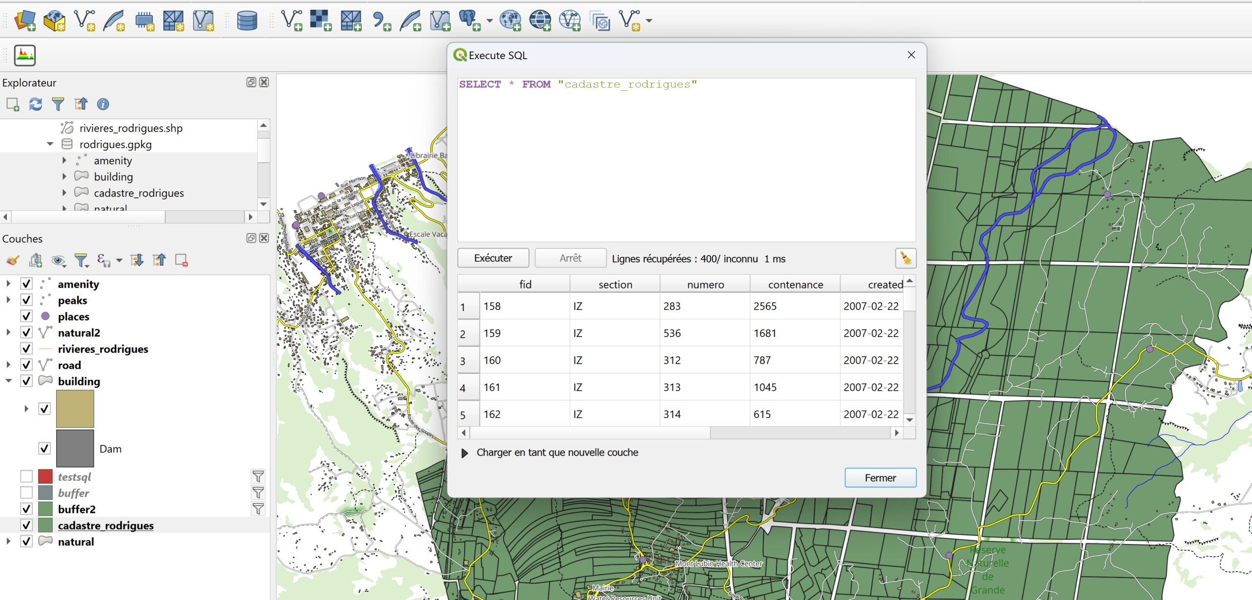
Blog GIS & Territories

GIS coaching for territorial management.

  • Blog – English
  • Tutorials
    • Leaflet Initiation
  • All Content
  • Old Maps
  • Plugins QGis(en)
    • FuzzyAttributes(en)
  • About/Contact
  • English
    • Français
    • English
    • Español
    • Português

Author: Atilio Francois

7 March 20248 May 2025 Atilio Francois No Comments
  • Non classé

Creation of a Geopackage database for ENC maps (part 2: add symbology)

The first part of the Collaborative Financing for the Integration of Marine Data in QGIS project has been completed, thanks to contributions from ORANGE Marine, Geoconceptos Uruguay, Janez Avzec and Gaetan Mas. Our warmest thanks to…

Read More
  • QGis

Creation of a Geopackage database for ENC maps (Part 1: building the database)

The first part of the Collaborative Financing for the Integration of Marine Data in QGIS project has been completed, thanks to contributions from ORANGE Marine, Geoconceptos Uruguay, Janez Avzec and Gaetan Mas. Our warmest thanks to…

Read More
11 January 202411 January 2024 Atilio Francois No Comments
  • Non classé

Collaborative Funding for Marine Data Integration in QGIS

Dear friends of the marine community and GIS enthusiasts, We’re delighted to present an exciting project aimed at improving the visualization of marine data in QGIS. Our goal is to make this information more accessible, understandable…

Read More
9 January 20248 January 2024 Atilio Francois No Comments
  • Lidar
  • QGis

Lidar with QGis: Interpolation of the Digital Elevation Model (DEM)

In this article you’ll find out how to apply two types of interpolation (TLI and IDW) simultaneously to a LIDAR point cloud, having segmented the cloud into two types of zone. Tutorial HD LIDAR data processing…

Read More
19 December 202318 December 2023 Atilio Francois 2 Comments
  • QGis

Displaying S57 nautical charts in QGis 3.X

In this article you’ll find out how to load an ENC file in S57 format into QGis 3.34 and download a nautical chart symbology to apply to it. As the previous article on the S57 format…

Read More
12 October 202312 October 2023 Atilio Francois No Comments
  • QGis

Installing the QGIS- Semi-Automatic Classification (SCP) v 8.0 plugin

This article describes the installation of version 8.0.3 of the QGis SCP (semi-automatic classification) plugin on a 64-bit Windows machine. The new version of the QGis image classification plugin (SCP) is a little more complicated than…

Read More

Posts pagination

« Previous 1 … 6 7 8 9 10 … 52 Next »

Mastodon Follow me on Mastodon
Voir le profil de atilio francois sur LinkedIn

Recent articles

  • Converting a raster into fuzzy values with FuzzyAttributes V2
  • Consultation and negotiation: the contribution of fuzzy logic
  • PostGIS 3.6 released – 3D, raster, and topology take a leap forward
  • Creating awareness maps with QGIS: the equivalent of the Above and Below style
  • From Boolean analysis to fuzzy logic in a GIS: a concrete example

Recent comments

  1. Atilio Francois on How to develop an application with pgrouting in Windows (1)25 August 2025

    You're right — since 2019 Geofabrik no longer provides plain `.osm` files, only the compressed `.osm.pbf` format. The tool **osm2pgrouting**…

  2. Simon on How to develop an application with pgrouting in Windows (1)25 August 2025

    The osm downloads don't appear to be available, just osm.pfb And osm2pgrouting on Windows doesn't like pbf "not well formed…

  3. Arno on Portable version of QGis 3.32.021 August 2025

    I just want to thank you. It works.

  4. Atilio Francois on Portable version of QGis 3.32.015 May 2025

    What is the link between the qgis update and the portable version? A portable version cannot be updated; it must…

  5. Hugo on Portable version of QGis 3.32.014 May 2025

    For me, the error message complaining that qgis_app.dll is missing started appearing following the most recent QGIS update.

All articles by category (click on a category to display article extracts)

(You can copy the RSS link for each category separately)

  • ArcGis (1)
  • Arcgis Pro (1)
  • bibliography (1)
  • Database (12)
    • PostgreSQL (9)
    • Spatialite (3)
  • english posts (20)
  • Felt (3)
  • Geoserver (5)
  • GIS and management (2)
  • Lidar (10)
  • Logique floue (1)
  • Non classé (206)
  • Outils divers (2)
  • Postgis (2)
  • QGis (59)
    • Plugin (15)
  • webmapping (9)

  • Blog – English
  • Tutorials
  • All Content
  • Old Maps
  • Plugins QGis(en)
  • About/Contact
  • English
Copyright 2018. All rights reserved | Theme: Blog Mantra by LilyTurf Themes