Blog GIS & Territories

GIS coaching for territorial management.

  • Blog – English
  • Tutorials
    • Leaflet Initiation
  • All Content
  • Old Maps
  • Plugins QGis(en)
    • S57Manager(en)
    • FuzzyAttributes(en)
  • About/Contact
  • English
    • Français
    • English
    • Español
    • Português

Tag: GIS

1 April 202615 March 2026 Atilio Francois No Comments
  • QGis
  • Tutorial

[EN]Understanding Projections in QGIS: A Simple Guide

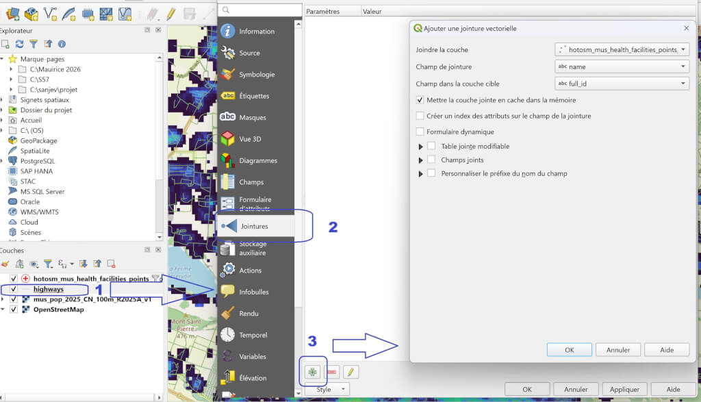
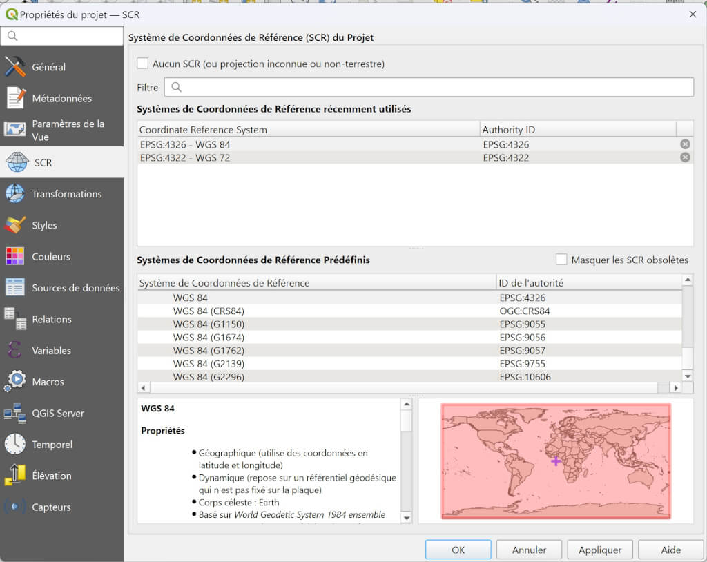
Projections and coordinate reference systems (CRS) are essential concepts when working with geographic data in QGIS. Incorrect handling of projections can cause significant misalignment between layers. When working with geographic data in QGIS, projections and coordinate…

Read More
25 March 202615 March 2026 Atilio Francois No Comments
  • QGis
  • Tutorial

[EN]Joining a Table in QGIS: A Simple Guide

In QGIS, it is common to associate data from an external table with a geographic layer. For example, you may have a layer of municipalities and a CSV file containing demographic statistics. To combine this information,…

Read More
12 March 202614 March 2026 Atilio Francois No Comments
  • QGis

[EN]Portable QGIS 4.0 for Windows – Download and use QGIS without installation

QGIS is one of the most widely used open source GIS (Geographic Information System) software programs in the world. It allows users to view, analyze, and map geographic data using a wide range of tools. Many…

Read More
  • Geospatial Technologies
  • Spatial Analysis & GIS

[EN]Quantum Computing and GIS – Experiments, Limitations, and Perspectives

Article 3/3 After the promises, a return to reality is required.Is quantum computing already usable in geomatics? What experiments actually exist? And on what timeline could concrete contributions to GIS realistically be expected? This final article…

Read More
9 March 20269 March 2026 Atilio Francois No Comments
  • Geospatial Technologies
  • QGis
  • Spatial Analysis & GIS

[EN]QGIS 4.0 Released: Discover the New Features

The new major version of QGIS has been released. QGIS 4.0 marks an important milestone in the evolution of the open-source GIS software, bringing a modernized interface, numerous performance improvements and the migration to Qt 6.…

Read More
4 March 202616 February 2026 Atilio Francois No Comments
  • Geospatial Technologies
  • Non classé
  • Spatial Analysis & GIS

[EN]Potential applications of quantum computing in GIS

Article 2/3 Once the foundations have been laid, the central question remains: what could quantum computing actually be used for in GIS?Rather than speculating in abstract terms, this article explores the domains where the challenges faced…

Read More

Posts pagination

1 2 Next »

Mastodon Follow me on Mastodon
Voir le profil de atilio francois sur LinkedIn

Recent articles

Recent comments

posts

  1. Atilio Francois on How to develop an application with pgrouting in Windows (1)25 August 2025

    You're right — since 2019 Geofabrik no longer provides plain `.osm` files, only the compressed `.osm.pbf` format. The tool **osm2pgrouting**…

  2. Simon on How to develop an application with pgrouting in Windows (1)25 August 2025

    The osm downloads don't appear to be available, just osm.pfb And osm2pgrouting on Windows doesn't like pbf "not well formed…

  3. Arno on Portable version of QGis 3.32.021 August 2025

    I just want to thank you. It works.

  4. Atilio Francois on Portable version of QGis 3.32.015 May 2025

    What is the link between the qgis update and the portable version? A portable version cannot be updated; it must…

  5. Hugo on Portable version of QGis 3.32.014 May 2025

    For me, the error message complaining that qgis_app.dll is missing started appearing following the most recent QGIS update.

All articles by category (click on a category to display article extracts)

(You can copy the RSS link for each category separately)

  • ArcGis (1)
  • Arcgis Pro (1)
  • bibliography (1)
  • Database (12)
    • PostgreSQL (9)
    • Spatialite (3)
  • english posts (20)
  • Felt (3)
  • Geoserver (5)
  • Geospatial Technologies (4)
    • Spatial Analysis & GIS (4)
  • GIS and management (2)
  • IA(en) (3)
  • Lidar (10)
  • Logique floue (2)
  • Non classé (207)
  • Outils divers (2)
  • Outils et méthodes (5)
    • Images (5)
  • Postgis (2)
  • QGis (74)
    • Plugin (24)
    • Tutorial (3)
  • S57 (5)
  • webmapping (9)

  • Blog – English
  • Tutorials
  • All Content
  • Old Maps
  • Plugins QGis(en)
  • About/Contact
  • English
Copyright 2018. All rights reserved | Theme: Blog Mantra by LilyTurf Themes