Blog GIS & Territories

GIS coaching for territorial management.

  • Blog – English
  • Tutorials
    • Leaflet Initiation
  • All Content
  • Old Maps
  • Plugins QGis(en)
    • FuzzyAttributes(en)
  • About/Contact
  • English
    • Français
    • English
    • Español
    • Português

Tag: plugins

18 May 202316 May 2023 Atilio Francois No Comments
  • QGis

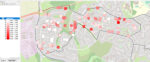
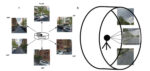
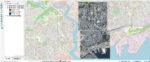
QGis plugin Green View Index: comparison with aerial images

The QGIS Green View Index plugin is a powerful tool to measure the vegetation cover of a given area. It is interesting to see what it brings compared to the classical processing based on vertical aerial…

Read More
17 May 202320 May 2023 Atilio Francois No Comments
  • QGis

QGis Green View Index plugin tutorial

The Green View Index for QGIS is a plugin that performs the three main procedures necessary to calculate the GVI for a given area: We are publishing a series of three articles: 1-Green View index concepts…

Read More
16 May 202320 May 2023 Atilio Francois No Comments
  • QGis

The Green View Index plugin in QGis

The QGIS Green View Index plugin is a powerful tool for measuring the vegetation cover of a given area. It is easy to use and provides valuable information to urban planners, landscape architects and environmentalists. By…

Read More

Mastodon Follow me on Mastodon
Voir le profil de atilio francois sur LinkedIn

Recent articles

  • Exporting a QGIS layout to SVG: uses, limitations, and solutions
  • Associating points with their municipality or zone: simple spatial joins with MMQGIS
  • Geocoding place names and finding an address from GPS coordinates with QGIS + MMQGIS
  • Work or train independently: create a portable QGIS environment
  • Building a consistent, reusable QGIS environment: bookmarks, project templates and automation

Recent comments

  1. Atilio Francois on How to develop an application with pgrouting in Windows (1)25 August 2025

    You're right — since 2019 Geofabrik no longer provides plain `.osm` files, only the compressed `.osm.pbf` format. The tool **osm2pgrouting**…

  2. Simon on How to develop an application with pgrouting in Windows (1)25 August 2025

    The osm downloads don't appear to be available, just osm.pfb And osm2pgrouting on Windows doesn't like pbf "not well formed…

  3. Arno on Portable version of QGis 3.32.021 August 2025

    I just want to thank you. It works.

  4. Atilio Francois on Portable version of QGis 3.32.015 May 2025

    What is the link between the qgis update and the portable version? A portable version cannot be updated; it must…

  5. Hugo on Portable version of QGis 3.32.014 May 2025

    For me, the error message complaining that qgis_app.dll is missing started appearing following the most recent QGIS update.

All articles by category (click on a category to display article extracts)

(You can copy the RSS link for each category separately)

  • ArcGis (1)
  • Arcgis Pro (1)
  • bibliography (1)
  • Database (12)
    • PostgreSQL (9)
    • Spatialite (3)
  • english posts (20)
  • Felt (3)
  • Geoserver (5)
  • GIS and management (2)
  • Lidar (10)
  • Non classé (206)
  • Outils divers (2)
  • Postgis (1)
  • QGis (52)
    • Plugin (9)
  • webmapping (9)

  • Blog – English
  • Tutorials
  • All Content
  • Old Maps
  • Plugins QGis(en)
  • About/Contact
  • English
Copyright 2018. All rights reserved | Theme: Blog Mantra by LilyTurf Themes