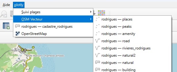
Blog GIS & Territories

GIS coaching for territorial management.

  • Blog – English
  • Tutorials
    • Leaflet Initiation
  • All Content
  • Old Maps
  • Plugins QGis(en)
    • FuzzyAttributes(en)
  • About/Contact
  • English
    • Français
    • English
    • Español
    • Português

Category: QGis

19 March 202418 March 2024 Atilio Francois No Comments
  • QGis

Update(1) :ENC database with Geopackage under QGis

Following the publication of the first part of our work on Geopackages, our work with PostgreSQL/Postgis has enabled us to make a series of further advances. In this article, you’ll find an updated procedure for importing…

Read More
  • QGis

Creation of a Geopackage database for ENC maps (Part 1: building the database)

The first part of the Collaborative Financing for the Integration of Marine Data in QGIS project has been completed, thanks to contributions from ORANGE Marine, Geoconceptos Uruguay, Janez Avzec and Gaetan Mas. Our warmest thanks to…

Read More
9 January 20248 January 2024 Atilio Francois No Comments
  • Lidar
  • QGis

Lidar with QGis: Interpolation of the Digital Elevation Model (DEM)

In this article you’ll find out how to apply two types of interpolation (TLI and IDW) simultaneously to a LIDAR point cloud, having segmented the cloud into two types of zone. Tutorial HD LIDAR data processing…

Read More
19 December 202318 December 2023 Atilio Francois 2 Comments
  • QGis

Displaying S57 nautical charts in QGis 3.X

In this article you’ll find out how to load an ENC file in S57 format into QGis 3.34 and download a nautical chart symbology to apply to it. As the previous article on the S57 format…

Read More
12 October 202312 October 2023 Atilio Francois No Comments
  • QGis

Installing the QGIS- Semi-Automatic Classification (SCP) v 8.0 plugin

This article describes the installation of version 8.0.3 of the QGis SCP (semi-automatic classification) plugin on a 64-bit Windows machine. The new version of the QGis image classification plugin (SCP) is a little more complicated than…

Read More
30 August 202330 August 2023 Atilio Francois No Comments
  • Lidar
  • QGis

QGis for LIDAR: digital feature model (DEM) with Open Lidar Tools.

In this article you’ll find out how to create a Digital Feature Model in just a few clicks and visualize the results, thanks to the Open Lidar Toolbox plugin. Tutorial HD LIDAR data processing with QGis…

Read More

Posts pagination

« Previous 1 … 3 4 5 6 7 … 10 Next »

Mastodon Follow me on Mastodon
Voir le profil de atilio francois sur LinkedIn

Recent articles

  • From Boolean analysis to fuzzy logic in a GIS: a concrete example
  • Union in GIS: choosing between overlay, merge, unary union, and dissolve
  • Fuzzy logic and GIS (2/2): from transformation to aggregation of spatial data
  • Fuzzy logic and GIS (1/2): an alternative to all-or-nothing for geographic analysis
  • Exporting a QGIS layout to SVG: uses, limitations, and solutions

Recent comments

  1. Atilio Francois on How to develop an application with pgrouting in Windows (1)25 August 2025

    You're right — since 2019 Geofabrik no longer provides plain `.osm` files, only the compressed `.osm.pbf` format. The tool **osm2pgrouting**…

  2. Simon on How to develop an application with pgrouting in Windows (1)25 August 2025

    The osm downloads don't appear to be available, just osm.pfb And osm2pgrouting on Windows doesn't like pbf "not well formed…

  3. Arno on Portable version of QGis 3.32.021 August 2025

    I just want to thank you. It works.

  4. Atilio Francois on Portable version of QGis 3.32.015 May 2025

    What is the link between the qgis update and the portable version? A portable version cannot be updated; it must…

  5. Hugo on Portable version of QGis 3.32.014 May 2025

    For me, the error message complaining that qgis_app.dll is missing started appearing following the most recent QGIS update.

All articles by category (click on a category to display article extracts)

(You can copy the RSS link for each category separately)

  • ArcGis (1)
  • Arcgis Pro (1)
  • bibliography (1)
  • Database (12)
    • PostgreSQL (9)
    • Spatialite (3)
  • english posts (20)
  • Felt (3)
  • Geoserver (5)
  • GIS and management (2)
  • Lidar (10)
  • Logique floue (1)
  • Non classé (206)
  • Outils divers (2)
  • Postgis (1)
  • QGis (56)
    • Plugin (12)
  • webmapping (9)

  • Blog – English
  • Tutorials
  • All Content
  • Old Maps
  • Plugins QGis(en)
  • About/Contact
  • English
Copyright 2018. All rights reserved | Theme: Blog Mantra by LilyTurf Themes