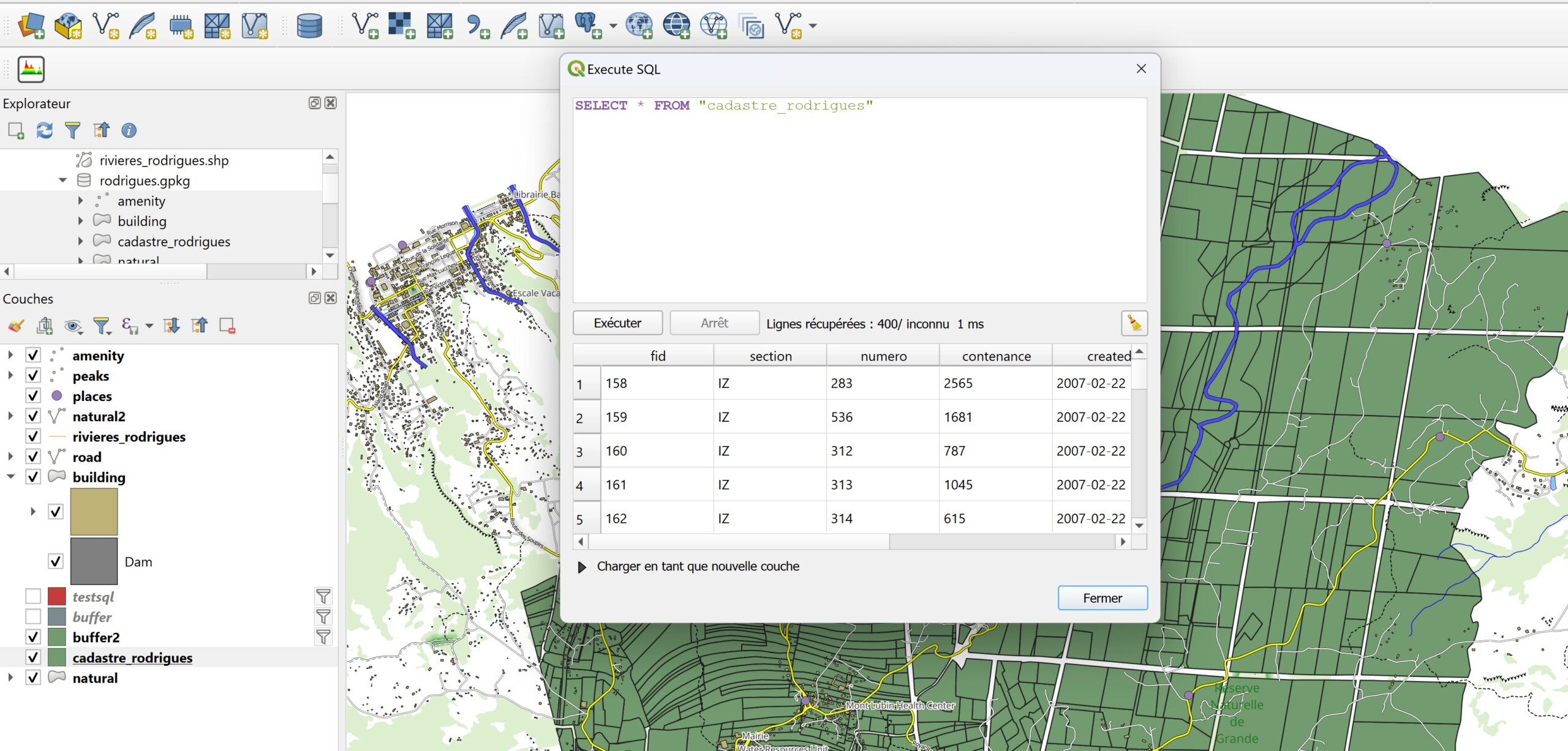
Blog GIS & Territories

GIS coaching for territorial management.

  • Blog – English
  • Tutorials
    • Leaflet Initiation
  • All Content
  • Old Maps
  • About/Contact
  • English
    • Français
    • English
    • Español
    • Português

Tag: qgis

18 July 202313 July 2023 Atilio Francois No Comments
  • Lidar

LIDAR data in QGis 3.32

Among many improvements, version 3.32 introduces the long-awaited feature of native point cloud processing in QGIS, enabling QGIS Desktop to become a powerful LiDAR data processing utility. Before publishing a tutorial on the new features, I’ve…

Read More
13 July 202311 July 2023 Atilio Francois No Comments
  • QGis

QGis network analysis tools:service area

In network analysis with QGIS, a service area refers to a geographic zone that is covered or served by a specific transportation or distribution network. This can include elements such as roads, public transit lines, water…

Read More
11 July 202310 July 2023 Atilio Francois No Comments
  • QGis

QGis shortest path network analysis tools

Two types of network analysis tools are available: In network analysis with QGIS, shortest path refers to the shortest route between two given points in a road or transportation network. It’s about finding the optimal route…

Read More
6 July 20235 July 2023 Atilio Francois No Comments
  • QGis

Netwotk Analysis with QGis

We’ll look at how to download and prepare OpenStreetMap data for a network analysis, then at all the QGis processes grouped together under the heading Network Analysis.

Read More
4 July 20233 July 2023 Atilio Francois 7 Comments
  • QGis

Portable version of QGis 3.32.0

You can download a portable version of QGis 3.32.0 from this link. The compressed file is 1.4 GB. Once decompressed, it will occupy 2.6 GB on disk.

Read More
29 June 202325 June 2023 Atilio Francois No Comments
  • Felt
  • QGis

New Felt plugin for QGis

Felt has just released a new plugin for the QGIS community: Add to Felt. QGIS users can now create Felt maps directly from QGIS projects thanks to the new QGIS plugin.

Read More

Posts pagination

« Previous 1 2 3 4 5 6 … 8 Next »

Mastodon Follow me on Mastodon
Voir le profil de atilio francois sur LinkedIn

Recent articles

  • QGis and geoparquet
  • ENC maps in QGis with Postgis(1)
  • Postgis:table with multiple geometries
  • Leaflet: responsive
  • MBtiles & Leaflet

Recent comments

  1. Atilio Francois on Portable version of QGis 3.32.015 May 2025

    What is the link between the qgis update and the portable version? A portable version cannot be updated; it must…

  2. Hugo on Portable version of QGis 3.32.014 May 2025

    For me, the error message complaining that qgis_app.dll is missing started appearing following the most recent QGIS update.

  3. Atilio Francois on Portable version of QGis 3.32.07 May 2025

    Hello The problem with the portable version is that it's very dependent on the particular configuration of the machine. The…

  4. NotFred on Portable version of QGis 3.32.07 May 2025

    I have never had QGIS installed in my machine (it's a brand new laptop) and I get the same error,…

  5. Atilio Francois on Portable version of QGis 3.32.028 April 2025

    The file is present in the download ...\QGIS 3.32.0\QGIS 3.32.0\apps\qgis\bin The error message probably comes from a previous installation of…

All articles by category (click on a category to display article extracts)

(You can copy the RSS link for each category separately)

  • ArcGis (1)
  • Arcgis Pro (1)
  • bibliography (1)
  • Database (12)
    • PostgreSQL (9)
    • Spatialite (3)
  • english posts (20)
  • Felt (3)
  • Geoserver (5)
  • GIS and management (2)
  • Lidar (10)
  • Non classé (206)
  • Outils divers (2)
  • Postgis (1)
  • QGis (37)
  • webmapping (9)

  • Blog – English
  • Tutorials
  • All Content
  • Old Maps
  • About/Contact
  • English
Copyright 2018. All rights reserved | Theme: Blog Mantra by LilyTurf Themes