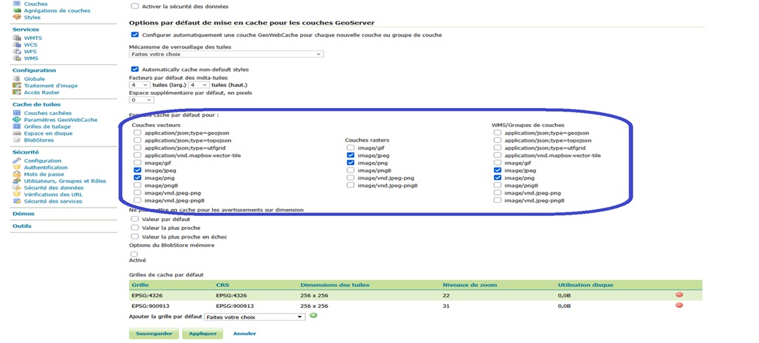
Blog GIS & Territories

GIS coaching for territorial management.

  • Blog – English
  • All Content
  • Old Maps
  • About/Contact
  • Forums.
  • EnglishEnglish
    • FrançaisFrançais
    • EnglishEnglish
    • EspañolEspañol
    • PortuguêsPortuguês

Tag: tiles

2 May 202324 June 2023 Atilio Francois No Comments
  • Felt
  • QGis

Integrating a WMTS raster tile service in QGis 3 and Felt

What is WMTS? A good example of a WMTS service is OpenStreetMap. It consists of an address to which client programs can request geotagged images. When you load OSM into QGis, the program connects to the…

Read More
  • english posts
  • Geoserver

Advanced Geoserver : tiling (quick start)

In the previous article (Advanced Geoserver: tiling (principles) we have explored the different concepts regarding the tiling mapping. In this article we will discuss how to implement those applications using Geoserver. In order to run the…

Read More
  • Geoserver

Advanced Geoserver: tiling (principles)

One of the most interesting features of Geoserver is its ability to manage a map server. In this article we will explain how to take full advantage of this feature.

Read More
  • Blog – English
  • All Content
  • Old Maps
  • About/Contact
  • Forums.
  • EnglishEnglish
Copyright 2018. All rights reserved | Theme: Blog Mantra by LilyTurf Themes