With version 10.3, ESRI has announced a new possibility for the geodatabase file: you can make them non-copy and you can give them a deadline access date. Firstly, let’s discuss all you have to do, then a nice example of how to make yourself absurd by living in isolation.
Firstly, let’s consider the ESRI terms in the descriptive page of this new feature :
” You can share the geodatabase data file with others users and apply a license that determines the data use authorized duration and whether it is possible or not to export feature classes.
For example , if you are teacher and you want to communicate data to your students during a semester, you can make available a geodatabase file that contains data licensed to expire at the end of the semester. Otherwise , if you hire a service provider to analyze a set of data, but you do not want the provider being able to export the data , you can make available a geodatabase file licensed that does not allow to export the data . ”
Therefore, the tool answers to real needs. This article is not a discussion between the data which is free or not. Let’s agree that there are instances when, indeed , we can limit access to certain data .
In this case, we are ArcGis users with special needs. We are lucky to, finally, have tools enabling us to provide some data not likely to be copied or that their access is limited in time.
How does it work ?
In the toolbox Geodatabase file , you have two tools to assign a license to a file geodatabase :
- the first is used to generate a license definition file (file with the extension licdef.): the tool uses as input a geodatabase file with the data included and generates a geodatabase file locked and a definition licence file containing the information of the locked geodatabase. At this stage , the locked geodatabase file is no longer accessible by either ArcMap or ArcCatalog.
- the second is used to generate a license file (file with the extension sdlic.): the tool takes as input the locked geodatabase file as well as the . licdef file and configure authorization/non authorization options to copy as well as the consultation deadline , that is registered in the license file . sdlic
At this stage , the secured file geodatabase is still not accessible with ArcMap or ArcCatalog. To do this, you must open the License Administrator and add the file . sdlic in the list of data licenses .
From there, you can access your geodatabase file , subject to registered limitations in the license: copy right , deadline .
An example Let’s take an example with a geodatabase containing Natura 2000 areas and Znieff :

The first step is to create the license definition file with the Generate a geodatabase licensed file tool. The created geodatabase , Natura2000_Protected, cannot be used in ArcMap and ArcCatalog. If you try to load a layer you get the following error message :

The second step is to create a license file with the Generateageodatabaselicensefile tool:

You have two configuration settings :
- To allow exporting vector data: DENY_EXPORT or ALLOW_EXPORT
- Expiration date.
The file Natura2000_Protected.sdlic is created .
The fact that the file exists does not unlock access to the geodatabase. If you try to load a layer , you will always get the error messages .
The third step is to add the geodatabase license in your installation data licenses.
Small detail , you have to close Arcmap and ArcCatalog to achieve this operation . Open the AdministratorArcGis :

Select Data licenses then click Add a license .
Check the file Natura2000_Protected.sdlic and click OK.
Close the window of the ArcGIS Administrator. Now you can access the protected file geodatabase :

Now, you can send the protected geodatabase and the file . sdlic to your interlocutor . You can go to sleep peacefully, your data will not be copied or used beyond the date you have set.
How does it not work?
As for the quiet sleep, it will come to an end !
Of course , every time there are safety, there are small smart to look for flaws. Let’s forget them ! What we will now do is outside the hackage or bypass doubtful a function , in short , we will only do normal and trivial.
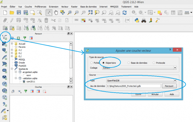
I am QGis user , I get a file geodatabase (protected or not). First step, I load the layer in QGis

We click on the Add a vector layer , in Source type we choose Directory , in Type we select OpenFileGDB and in Data set, our protected file geodatabase shows. Click on the Open button :
We see that the ZoneNature2000 layer has 0 entities . while GDB_SecureCopy_ZonesNatura2000 has 25885. We select obviously this latest and …

The data is loaded without any problem. We could say that, maybe, just the geometries are loaded and that the attribute table , at least , has been encrypted or protected. Click OpenAttributeTable and …

And everything is in clear as water . Well, we can them without any interference, but we have protected the data. We try to save this layer as a shapefile, right click on the layer -> Saveas:

We click OK, and …

That’s our copy of the data ready and complete .
Conclusion
We forgot to say that once the expiry date is past it continues to work the same …
We have, just, used QGis in the most classic way, legally and orthodoxly . No tampering or tricking!
Finally, we spent a quarter of an hour protecting our data while, only, 30 seconds to load them and create a copy . By the way , the data is, mostly, protected from ourselves when using ArcGis.
If the mood of this article is rather ironic, it is that we mean it, if the lack of security is a concern , fake protections are a thousand times worse . How is an agreement suitable if it states that you cannot copy data if the data is protected? What is the use of adding that it will destroy the data at the end of the delivery if it will not be accessible after the deadline date?
And then, one should ask if those who develop and disseminate these tools are aware that there is a real world beyond ArcGis …