Loading Geopackage data into PostreQL/PostGis with QGis
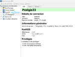
Among the different options to load data in Postgresql, we will see here the one that, in my opinion, is the easiest and fastest. We will simply use QGis and its Database Manager.
Read MoreGIS coaching for territorial management.
Among the different options to load data in Postgresql, we will see here the one that, in my opinion, is the easiest and fastest. We will simply use QGis and its Database Manager.
Read More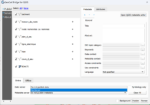
Although Geoserver has tools for uploading data layers, this operation can be simplified by exploiting the possibilities of QGis and the Geocat Bridge plugin. This plugin allows to load directly in Geoserver the data and symbologies…
Read More
The QGIS Green View Index plugin is a powerful tool to measure the vegetation cover of a given area. It is interesting to see what it brings compared to the classical processing based on vertical aerial…
Read More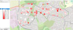
The Green View Index for QGIS is a plugin that performs the three main procedures necessary to calculate the GVI for a given area: We are publishing a series of three articles: 1-Green View index concepts…
Read More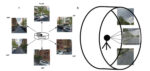
The QGIS Green View Index plugin is a powerful tool for measuring the vegetation cover of a given area. It is easy to use and provides valuable information to urban planners, landscape architects and environmentalists. By…
Read More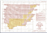
The Perry-Castañeda Library Map Collection, located at the University of Texas, is one of the largest digital map collections in the world. This collection contains maps of all continents and many countries, as well as topographic,…
Read More