New Felt plugin for QGis
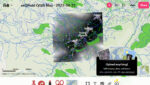
Felt has just released a new plugin for the QGIS community: Add to Felt. QGIS users can now create Felt maps directly from QGIS projects thanks to the new QGIS plugin.
Read MoreGIS coaching for territorial management.
Felt has just released a new plugin for the QGIS community: Add to Felt. QGIS users can now create Felt maps directly from QGIS projects thanks to the new QGIS plugin.
Read More
This article explores the fundamental concept of topology in GIS (Geographic Information Systems) and its application in the modeling and analysis of geospatial data. It examines in detail the different aspects of topology, such as spatial…
Read More
We’ll take up the example covered in the article Eliminating overlays and gaps between polygons in a layer (with QGis and Postgis) to see the same type of solution when you don’t have a PostgreSQL/Postgis database.…
Read More
For those unfamiliar with the joys of working with the French cadastre, you should know that if you have the opportunity to work with cadastral data corresponding to “Lieux-dits” (a subdivision of communes) you’ll find that…
Read More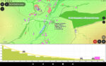
Here’s a 5-chapter tutorial on the new QGis feature in version 3.26: elevation profiles. Chapter 1: Profiles from vector layers Chapter 2: Profiles from raster layers Chapter 3: Profiles from point clouds (Lidar) Chapter 4: Profiles…
Read More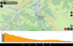
Here’s a 5-chapter tutorial on the new QGis feature in version 3.26: elevation profiles. Chapter 1: Profiles from vector layers Chapter 2: Profiles from raster layers Chapter 3: Profiles from point clouds (Lidar) Chapter 4: Profiles…
Read More