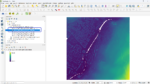
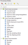
Blog GIS & Territories

GIS coaching for territorial management.

  • Blog – English
  • Tutorials
    • Leaflet Initiation
  • All Content
  • Old Maps
  • About/Contact
  • English
    • Français
    • English
    • Español
    • Português

Tag: qgis

18 May 202316 May 2023 Atilio Francois No Comments
  • QGis

QGis plugin Green View Index: comparison with aerial images

The QGIS Green View Index plugin is a powerful tool to measure the vegetation cover of a given area. It is interesting to see what it brings compared to the classical processing based on vertical aerial…

Read More
17 May 202320 May 2023 Atilio Francois No Comments
  • QGis

QGis Green View Index plugin tutorial

The Green View Index for QGIS is a plugin that performs the three main procedures necessary to calculate the GVI for a given area: We are publishing a series of three articles: 1-Green View index concepts…

Read More
16 May 202320 May 2023 Atilio Francois No Comments
  • QGis

The Green View Index plugin in QGis

The QGIS Green View Index plugin is a powerful tool for measuring the vegetation cover of a given area. It is easy to use and provides valuable information to urban planners, landscape architects and environmentalists. By…

Read More
9 May 20235 May 2023 Atilio Francois No Comments
  • QGis

Perry-Castañeda Library-southern europe 1943 maps: How to georeference?

The Perry-Castañeda Library Map Collection, located at the University of Texas, is one of the largest digital map collections in the world. This collection contains maps of all continents and many countries, as well as topographic,…

Read More
2 May 202324 June 2023 Atilio Francois No Comments
  • Felt
  • QGis

Integrating a WMTS raster tile service in QGis 3 and Felt

What is WMTS? A good example of a WMTS service is OpenStreetMap. It consists of an address to which client programs can request geotagged images. When you load OSM into QGis, the program connects to the…

Read More
1 May 20232 May 2023 Atilio Francois No Comments
  • QGis

How to find the coordinate system of a layer with QGis 3.X?

When working with spatial data in GIS software, you regularly encounter the problem of files that lack a clearly defined coordinate system. When a file lacks its coordinate system (CSR), it can lead to misaligned layers,…

Read More

Posts pagination

« Previous 1 … 5 6 7 8 Next »

Mastodon Follow me on Mastodon
Voir le profil de atilio francois sur LinkedIn

Recent articles

  • QGis and geoparquet
  • ENC maps in QGis with Postgis(1)
  • Postgis:table with multiple geometries
  • Leaflet: responsive
  • MBtiles & Leaflet

Recent comments

  1. Atilio Francois on Portable version of QGis 3.32.015 May 2025

    What is the link between the qgis update and the portable version? A portable version cannot be updated; it must…

  2. Hugo on Portable version of QGis 3.32.014 May 2025

    For me, the error message complaining that qgis_app.dll is missing started appearing following the most recent QGIS update.

  3. Atilio Francois on Portable version of QGis 3.32.07 May 2025

    Hello The problem with the portable version is that it's very dependent on the particular configuration of the machine. The…

  4. NotFred on Portable version of QGis 3.32.07 May 2025

    I have never had QGIS installed in my machine (it's a brand new laptop) and I get the same error,…

  5. Atilio Francois on Portable version of QGis 3.32.028 April 2025

    The file is present in the download ...\QGIS 3.32.0\QGIS 3.32.0\apps\qgis\bin The error message probably comes from a previous installation of…

All articles by category (click on a category to display article extracts)

(You can copy the RSS link for each category separately)

  • ArcGis (1)
  • Arcgis Pro (1)
  • bibliography (1)
  • Database (12)
    • PostgreSQL (9)
    • Spatialite (3)
  • english posts (20)
  • Felt (3)
  • Geoserver (5)
  • GIS and management (2)
  • Lidar (10)
  • Non classé (206)
  • Outils divers (2)
  • Postgis (1)
  • QGis (37)
  • webmapping (9)

  • Blog – English
  • Tutorials
  • All Content
  • Old Maps
  • About/Contact
  • English
Copyright 2018. All rights reserved | Theme: Blog Mantra by LilyTurf Themes